- Forum
- categories
- Help
- More advanced things
- Discussions about possible improvements
- In which countries of the world are the forum users located?
In which countries of the world are the forum users located?
27k views
Re: In which countries of the world are the forum users located?
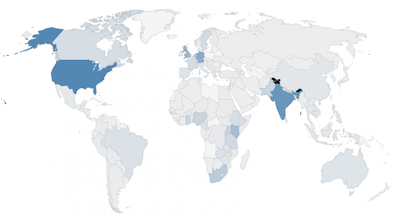
The map has black blotches when you view it in Chrome or Firefox. This is because of a browser issue. In IE, the map looks like this.
From here you can see that the zones coloured in black has nothing to do with member concentration. To the best of my knowledge, they are the disputed regions (parts of Kashmir and Arunachal Pradesh) between India, Pakistan and China.
Regards,
Shobana
Located at Deutsche Gesellschaft für Internationale Zusammenarbeit (GIZ) GmbH, Bonn, Germany
Follow us on facebook: www.facebook.com/susana.org, linkedin: www.linkedin.com/company/sustainable-sanitation-alliance-susana.
Attachments:
-
 map.png
(Filesize: 222KB)
Please Log in to join the conversation.
You need to login to replyRe: In which countries of the world are the forum users located?
Thanks, Elisabeth and Steffen. This projection is much better.
What are the black splotches to the east of Bhutan and to the north of India? (It looks like the greatest concentrations of members are hidden in secret valleys in the Himalayas. Are they in some Sanitation Shangrilas??)
Numbers under 100 seem too light and sort of look like zero. (Maybe a logarithmic scale could be good??)
I think it would be enough to search the database for members in certain countries (without them being named on the map). And this is a key function, as we could often want to know who is in a given country to deal with sanitation issues there.
Sorry, Steffen, that I always seem to be suggesting more work for you ... but we do not want you to get bored, right?
Best wishes,
Chris Canaday
Omaere Ethnobotanical Park
Puyo, Pastaza, Ecuador, South America
inodoroseco.blogspot.com
Please Log in to join the conversation.
You need to login to replyRe: In which countries of the world are the forum users located?
It would not be possible to display country- specific member details due to data protection. However, like Elisabeth suggested, we would consider specific requests for obtaining such information and see how we can proceed further.
(Posted by Shobana)
Located at Deutsche Gesellschaft für Internationale Zusammenarbeit (GIZ) GmbH, Bonn, Germany
Follow us on facebook: www.facebook.com/susana.org, linkedin: www.linkedin.com/company/sustainable-sanitation-alliance-susana.
Please Log in to join the conversation.
You need to login to reply- Elisabeth
-
- User is blocked
- Freelance consultant since 2012
Less- Posts: 3372
- Karma: 54
- Likes received: 932
Re: In which countries of the world are the forum users located?
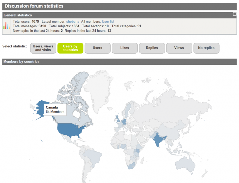
Chris, I have good news for you! Steffen looked into the issue of different map projections and he has now chosen this one, it's called "kavrayskiy-vii" projection:
See also here on the forum page:
forum.susana.org/forum/statistics?task=map
As Steffen wrote to me:
The last topic I found for google geochart: "Hello, the projections feature is still not quite polished in some cases, which is why it hasn't been announced yet. We currently support 4 projections: 'mercator', 'albers', 'lambert', and 'kavrayskiy-vii'. "
So for our map the last option (kavrayskiy-vii) is best choice is a great mixture between "politically correct" and common display like what people know
Looks pretty good to me.
About the "density" of SuSanA members per country (i.e. members per inhabitants), well that could be done in theory but keep in mind we are not doing a scientific analysis here. It's just meant to be a snapshot and we are not trying to get above a certain %-value for membership in each country. But if anyone is interested in this data, they can easily calculate it for themselves.
About displaying the names of people in countries. Here I can't speak for the secretariat, perhaps Trevor or Shobana will reply on this soon. My personal opinion is that it shouldn't be made generally available for data privacy reasons. But if someone has a specific reason - e.g. trying to organise a local SuSanA meeting - then I would suggest contact the SuSanA secretariat (This email address is being protected from spambots. You need JavaScript enabled to view it.) and perhaps they can make it available for a very defined purpose, or they could e-mail the members in that country and give them the opt-out function if they don't want to be contacted by that member. But this is just my personal suggestion, not an official answer by the secretariat.
Greetings,
Elisabeth
Freelance consultant on environmental and climate projects
Attachments:
-
 Newmap.png
(Filesize: 246KB)
Please Log in to join the conversation.
You need to login to reply- Sinaga
-
Less
- Posts: 2
- Likes received: 1
Re: In which countries of the world are the forum users located?
Great job on the map, it's really informative!
I wonder if it would also be useful if there's a data on which members are in which country? I think it can be useful for the forum users, especially if there's only small number of user in the member's country.
Ivan
Please Log in to join the conversation.
You need to login to replyHi,
I agree with Carol that it would be better to show % of each country's population that is a Forum member.
I am also surprised that a base map that shows Greenland as bigger than Africa was chosen (if we are trying to be politically correct). Here is a map that shows all countries in the correct size proportion to one another:
www.petersmap.com/
Best wishes,
Chris Canaday
Omaere Ethnobotanical Park
Puyo, Pastaza, Ecuador, South America
inodoroseco.blogspot.com
Please Log in to join the conversation.
You need to login to replyRe: Map showing the regional distribution of other forum users
I appreciate all the attention put into little things that can help make the Forum more user friendly. But a big country like the US having over 400 Forum users doesn't tell us much. Overall awareness about sustainable sanitation is growing here but is still very low and university-based Forum members come from all over.
If you take into account national populations South Africa, Canada, and Switzerland are impressive. If you add population density - which along with environmental conditions affects the need for and ease/difficulty of action - Bangladesh is really impressive.
I wouldn't worry too much about the colors for this particular set of indicators.
Carol
[End of Page 1 of the discussion]
Public Hygiene Lets Us Stay Human (PHLUSH)
1240 W. Sims Way #59, Port Townsend, Washington 98368 USA
Toilet availability is a human right and well-designed sanitation systems restore health to our cities, our waters and our soils.
Please Log in to join the conversation.
You need to login to reply- Elisabeth
-
- User is blocked
- Freelance consultant since 2012
Less- Posts: 3372
- Karma: 54
- Likes received: 932
Re: Map showing the regional distribution of other forum users
Thank you for your valuable feedback!
I asked Steffen (our IT developer) and here is what he answered:
I already played with the colors of the map and I would prefer to use the forum colors (green)! But the green is too bright and even if you use red the differences are too small. Only black to white will have more gradations ...
The problem is that you have only few countries with high rates and than 90% of the countries have to use the last 25% of gradations .... see screenshot
The list of countries I ordered in rows because for ordering by numbers it was confusing in columns , maybe if we put the numbers bold in front it makes sense ... for the list by name I agree it would be better ... but we have to use same ordering for both lists!
What do you reckon? What would be your preference?
Any further feedback from anyone?
Edit: Further feedback by Florian by e-mail:
So, for the colors, I meant more the graduation, independent on the color used. There are 3 bold countries and the rest is rather pale. Perhaps the graduation could be changed, with the countries with lower numbers getting also more bold colors…
For the sorting, I think with 4 columns and many rows, the intuitive way is to browse per columns, not per row (both for sorting by alphabet or by numbers). With the row sorting, it’s difficult to find a country…
Response by Steffen:
the gradients cannot be changed manually via Google Map Chart or only with high programming effort ... and what happens if you got more members in the mid range, every time you have to adjust it again ... so an automaticay algorithm should be used!
I said is no problem to sort the lists in columns but it would take a bit of time...
one or two colums will not look well and you wouldn't save much time ...
Regards,
Elisabeth
Freelance consultant on environmental and climate projects
Attachments:
-
 maps.jpg
(Filesize: 18KB)
Please Log in to join the conversation.
You need to login to replyTwo comments:
- the map looks a bit pale, probably stronger colors also for the countries with less members would make it look better...
- The list of countries would better be sorted by columns, not rows
Please Log in to join the conversation.
You need to login to replyRe: Map showing the regional distribution of other forum users
We are excited to announce that the forum users map is ready. Now, users can get an overview of the number of forum users (equals SuSanA members) from every country.
The image can be viewed in the link below:
forum.susana.org/forum/statistics?task=map
Please note that a small pop-up with the number of users appears for every country when one places the mouse over the desired country.
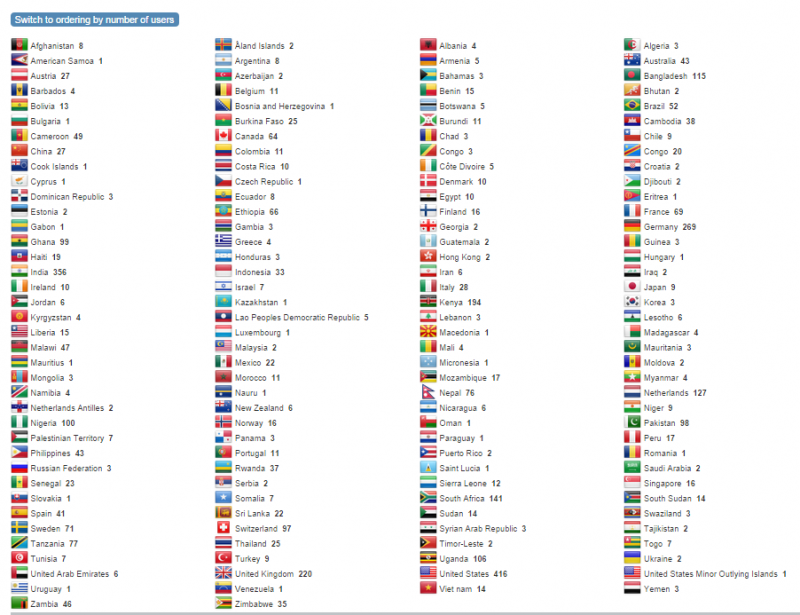
The top 10 countries with the most number of forum users (SuSanA members) are in descending order (but each with more than 100 members): United States, India, Germany, United Kingdom, Kenya, South Africa, Netherlands, Bangladesh, Uganda, Nigeria.
On the same page there is also a member list which you can order by alphabetical order or by number of members in a country. I have copied here the screenshot of countries in alphabetical order:
Happy viewing and analysing of the data!
(Posted by Shobana and Elisabeth)
Located at Deutsche Gesellschaft für Internationale Zusammenarbeit (GIZ) GmbH, Bonn, Germany
Follow us on facebook: www.facebook.com/susana.org, linkedin: www.linkedin.com/company/sustainable-sanitation-alliance-susana.
Attachments:
-
 Statistics...ries.png
(Filesize: 393KB)
-
 activitymap.png
(Filesize: 266KB)
Please Log in to join the conversation.
You need to login to reply- Elisabeth
-
- User is blocked
- Freelance consultant since 2012
Less- Posts: 3372
- Karma: 54
- Likes received: 932
Re: How can a user find out about the regional distribution of other forum users?
To your second point, do you have an example forum at hand where this has been implemented? Perhaps with the new version of Kunena (if we make that switch one day) it will also become possible...
Freelance consultant on environmental and climate projects
Please Log in to join the conversation.
You need to login to replyRe: How can a user find out about the regional distribution of other forum users?
- It should be relatively easy to produce a google map with clickable dots of the locations of member organisations if the data is available in a table (which you have in the Susana member database).
- Some forums software have a simple function for member maps, members can add their location to the profile and it is then shown on a map
Please Log in to join the conversation.
You need to login to reply- Forum
- categories
- Help
- More advanced things
- Discussions about possible improvements
- In which countries of the world are the forum users located?


